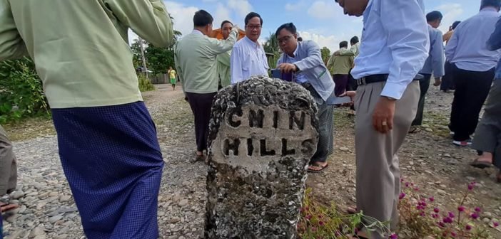
Chin land activists are concerned about the historic materials being consulted regarding the demarcation of Chin State.
The state, which borders Sagaing and Magwe regions and Rakhine State, has overlaps in the boundaries. A Union-level team is working to determine new demarcation lines, and the earliest known map of the area is a British colonial map dating back to 1938.
Mang Za Hkup, who is working with the Chin Land Affairs Network, said that he welcomes the move to re-demarcate the state’s borders, but that the 1938 map alone is not enough to complete the task fairly.
“The 1938 map is the earliest map drawn up by British officials. These officials did not hold discussions with local people when drawing up the map, so we can lose something. We should not rely on that map,” he told Khonumthung News. “We should reference the colonial British map, the map of the current administration, and the map of our ancestors. We will get the best results if we can draw references from these three maps.”
Mang Za Hkup pointed out that if the 1938 map is used, one of Chin State’s current townships will be reassigned to Sagaing Region.
Officials from the demarcation team, Chin State government, parliament, and the state’s townships held a meeting in the Parliament Affairs Hall in Hakha on January 16.
Salai Cieu Bik Thawng, secretary of the Chin National League for Democracy, said that the demarcation team must observe the situation on the ground situation and consider the administration system relied upon by the Chin community ancestrally.
“Before British colonial government came into our area, according to our history, our Ram Uk administrators ruled our Chin territory… including forests and mountains. We had our own territory,” he said, referring to the group’s hereditary leaders. “We have to determine how we can get our full area, so we have to reference the 1938 map, current Chin State map, and the territory of our ancestors. I think taking reference from one map is not enough to draw up the new demarcation of Chin State,” Salai Cieu Bik Thawng told Khonumthung News.
The state’s municipal minister Soe Htet agreed that the issue of demarcation is very sensitive.
“To avoid conflict, we have to negotiate with Sagaing, Magwe regions and Rakhine State. We have to discuss it with the Union government. One side cannot do it alone. We have to negotiate with all stakeholders,” he said, adding, “We can not make any mistakes.”
The demarcation team, Chin State government, and officials from the Sagaing government visited the border between Chin and Sagaing together on October 7, 2019. Following this, the officials said that they would set up new border posts on the line identified in the 1938 map.


